There is nothing more thrilling than hiking in the countryside, but it is not so thrilling to get lost. In today’s digital world, relying on the right technology might mean the difference between success and failure. In this guide, we will discuss the five best hiking GPS for outdoors. You should carry a hiking GPS in your backpack as a must-have item
Handheld GPS units for hiking are crucial for every novice or experienced hiker. This device provides precise navigation and enhances route safety for hiking. In addition, these little devices use satellite signals to provide real-time location tracking, helping hikers stay on track even in remote or difficult hiking areas.
Hiking GPS best devices provide a comprehensive solution for adventurers, with capabilities such as preloaded maps, waypoints, and inReach technology for emergency communication. A hiking GPS tracker is an effective gear that allows hikers to explore comfortably and enjoy the great outdoors.
In this article, we’ll understand why you should hike with GPS and also discover the best handheld hiking GPS receiver for hiking to help you select the perfect partner for your next adventure.
The 5 Best Handheld GPS Hiking
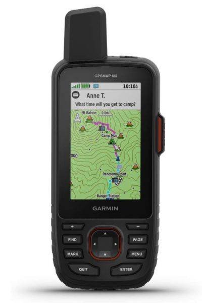
Garmin GPSMAP 66i
Specs
- Dimension: 6.2 x 16.3 x 3.5 cm
- MIL-STD-810: Yes (thermal, shock, water)
- Weight 230gm
- Display Type: Transflective color TFT
- Display Size: 1.5″ x 2.5″
- Display Resolution: 240 x 400 pixels
- Touchscreen: No
- Waterproof: Yes, IPX7
- Battery Type Rechargeable, internal lithium-ion
- Battery Life: Up to 35 hours at 10-minute tracking
Up to 200 hours at 30-minute tracking (power save mode) - Memory/History: 16 GB (user space varies based on included mapping)
Pros
- Smart notifications and connectivity
- Excellent reception
- Large buttons
- Big screen
- Includes topo maps and Bird’s Eye Imagery (without a subscription)
Cons
- Expensive
- Bulky
- Complicated connectivity between devices
The Garmin GPSMAP 66i is a powerful device, but it’s also simple to operate, even in the most difficult field situations. In terms of accuracy and dependability, the hiking GPS Garmin GPSMAP 66i is at the top of its class. It has a powerful quad-helix antenna and connects to more satellite networks more reliably and accurately than most other versions.
The GPSMAP 66i GPS device can sustain a satellite connection even in less-than-ideal conditions, such as under dense tree cover or in a narrow slot canyon. When in the cell service area, this gadget can connect to your smartphone and overlay real-time weather data on your maps.
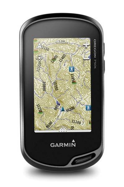
Garmin Oregon 750T
Specs
- Dimension: 6.1 x 11.4 x 3.3 cm
- Weight 209.8gm
- Display Type: Transflective color TFT touchscreen
- Display Size: 1.5″ x 2.5″
- Display Resolution: 241 x 400 pixels
- Touchscreen: Yes
- Waterproof: Yes, IPX7
- Battery Type: 2 AA batteries (not included); NiMH or Lithium recommended; rechargeable NiMH pack (optional)
- Battery Life: Up to 16 hours
- Memory/History: 4 GB (user space varies based on included mapping)
Pros
- Touchscreen interface that is easy to use
- Topo maps preloaded
- Easy geotagging and sharing with the camera
Cons
- Potential battery issues
- Expensive
The Garmin Oregon 750t strikes an excellent combination of functionality and ease of use, with capabilities that approach the highest-end models and a user-friendly interface of entry-level options. A dual-orientation touchscreen performs similarly to a smartphone and may be adjusted to improve operation when wearing gloves.
This Garmin 750t capability is a significant enhancement for winter customers searching for portable GPS units for ski touring, snowshoeing, or hunting. The large touchscreen, on the other hand, swiftly depletes the somewhat restricted 16-hour battery life – this is unlikely to be the item you choose if planning a trip.
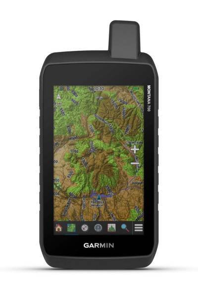
Garmin Montana 700
Specs
- Dimension: 8.76 x 18.30 x 3.27 cm
- Weight 397gm
- Lens Material: Chemically strengthened glass
- MIL-STD-810: Yes (thermal, shock, water, vibe)
- Display Type: WVGA transflective, dual orientation
- Display Size: 2.55″W x 4.25″H
- Display Resolution: 480 x 800 pixels
- Touchscreen: Yes
- Waterproof: Yes, IPX7
- Battery Type: Rechargeable lithium-ion (included) or 3 AA batteries (not included); lithium recommended
- Battery Life: GPS Mode: up to 18 hours. Expedition Mode: up to 330 hours
- Memory/History: 16 GB (user space varies based on included mapping)
Pros
- Big Touchscreen
- Fast processing speed
- Shock and water-resistant
Cons
- Bulky & heavy
- Costly
- Less practical as a handheld unit
The hiking GPS Garmin Montana 700 is an investment for professional outdoor sportsmen as a strong “handheld” portable GPS tracker. A high-resolution, 5-inch diagonal touchscreen provides improved display clarity and simple access to a highly customizable set of preloaded maps, as well as an unlimited subscription to Garmin’s satellite imagery library.
All of this is supported by excellent satellite reception, a quick CPU, and an accurate altimeter, barometer, and compass sensors. However, despite its versatility, the Montana 700 GPS is the largest and heaviest device in this study, making it less suitable for backpacking or hiking.
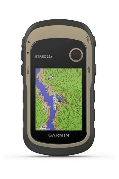
Garmin eTrex 32x
Specs
- Dimension: 5.4 x 10.3 x 3.3 cm
- Weight: 141.7gm
- Display Type: 2.2″ transflective, 65K color TFT
- Display Size: 1.4″ x 1.7″
- Display Resolution: 240 x 320 pixels
- Waterproof: Yes, IPX7
- Battery Type: 2 AA batteries (not included); NiMH or Lithium recommended
- Battery Life: 25 hours
- Memory/History: 8 GB
Pros
- Good price
- Compact and lightweight
- A barometric altimeter and an electronic compass are included.
Cons
- User-interface is boring
- Small display
- Low connectivity
The Garmin eTrex 32x is a compact and reliable handheld GPS device, designed for outdoor enthusiasts and hikers seeking simplicity without compromising essential features. With a color display that remains readable even in sunlight, the eTrex 32x provides a clear view of maps and navigation data. This rugged device is built to withstand the elements, making it suitable for various outdoor adventures.
Equipped with a 3-axis tilt-compensated electronic compass and a barometric altimeter, the eTrex 32x GPS offers precise navigation data, aiding users in maintaining their course and monitoring elevation changes. The eTrex 32x is an excellent choice for those who prioritize functionality and durability in a compact GPS device.
However, the eTrex 32x gps device offers an inexpensive solution with additional features as a plug-and-play choice for straightforward navigation or as a sturdy, small, and capable GPS for excursions.
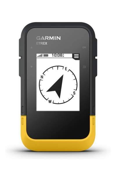
Garmin eTrex® SE
Specs
- Lens Material: Chemically strengthened glass
- Dimension: 6.1 x 10.0 x 3.3 cm
- Weight: 156.5 gm
- Display Type: 2.2″ transflective, monochrome
- Display Size: 1.3″W x 1.7″H
- Display Resolution: 240 x 320 pixels
- Waterproof: Yes, IPX7
- Battery Type: 2 AA batteries
- Battery Life: 168 hours in standard mode; 1,800 hours in expedition mode
- Memory/History: 28 MB
Pros
- Excellent battery life
- Connectivity with the Garmin Explore app
- Multi-GNSS support
- Supports real-time weather forecasting
Cons
- Black and white screen
- AA battery supply may not be for everyone
The Garmin eTrex SE fits perfectly in your palm and has a 2.2″ diagonal black and white screen. When compared to the tried-and-true eTrex 22x, the new SE model has a significantly longer battery life — 168 hours in regular mode; 1,800 hours in expedition mode — as well as full Global Navigation Satellite System reception. There’s also support for the Garmin Explore app. The pairing is fantastic.
The Garmin eTrex SE represents a market transition toward GPS systems with strong satellite reception, long battery life, and wireless connectivity. However, these innovative designs forego a complicated screen in favor of using your phone’s superior screen for tasks such as mapping and route planning.
This two-device method isn’t for everyone (and we’re not saying it’s necessary — the Garmin eTrex SE has all the legs it needs to stand on its own), but for those who find their phone accompanying them on their adventures, it’s a best-of-both-worlds solution that will keep your GPS powered on for longer, and your mapping much more enjoyable.
Check out our article Essential Hiking Gear before you head out on a camp. You will learn what additional gear is essential to take outdoors
Conclusion
GPS units are useful when needed, however they are not cheap. Choosing the best hiking GPS system is a critical decision that can considerably improve your outdoor excursions. The reviewed devices provide a range of functions to meet a variety of preferences and needs. You can pick any GPS from the list based on your needs and budget.
FAQ’s
Why Should I get a GPS for hiking?
A GPS device is highly suggested for outdoor adventure. Hiking GPS handheld allows you to track your exact location, navigate unfamiliar terrain, and help in emergencies. Modern GPS systems frequently have extra features such as preloaded maps, altitude information, and the capacity to send distress signals, making them excellent hiking equipment.
How do you use GPS when hiking?
When hiking, using GPS involves several steps:
- Confirm that your GPS device is completely charged.
- Turn on the GPS devices and wait for satellite signals.
- Select or input your destination or waypoints.
- To stay on the route, follow the on-screen guidance cues.
- Take backup batteries or a power bank to extend battery life.
- Familiarize yourself with the device’s functionality, such as waypoint marking and route tracking.
Is GPS better than maps?
GPS and maps serve different purposes and the decision depends on personal preference and conditions. Moreover, GPS provides real-time navigation, precise location monitoring, and other functionality such as route planning. Maps, on the other hand. In particular, this device provides a more comprehensive overview of the area and can aid in trip planning. A mix of GPS and maps is often excellent for thorough navigation.
How accurate are hiking GPS?
Hiking GPS locator is generally quite accurate, with many achieving location accuracy within a few meters. The accuracy can be affected by factors like extensive tree cover, tall buildings, or deep canyons can reduce accuracy, although modern GPS technology, including multi-constellation capability, reduces these concerns.
Can I use my phone as a hiking GPS?
Yes, smartphones can be used as hiking GPS devices. Many hiking GPS app, such as Gaia GPS, AllTrails, or Google Maps, offer GPS tracking and offline map functionality. However, it’s essential to consider battery life, the potential lack of signal in remote areas, and the durability of your phone when relying on it as your primary navigation tool.